Holland Landing
View map of Holland Landing area
Pink = Already 40 km/hr Green = Existing Road changing to 40km/hr
Blue = Development roads proposed at 40km/hr Yellow = School area reduced by 10km/hr

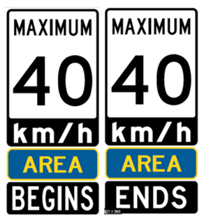
Streets changing to 40km/hr or proposed to be 40km/hr
- Acacia Court
- Anchor Court
- Beckett Avenue
- Beebalm Lane
- Blackstone Court
- Brent Road
- Byblos Court
- Chapman Street
- Charlotte Abby Drive
- Charmuse Lane
- Christopher Street
- Church Street
- Cloverridge Avenue
- Crimson King Way
- Cyprus Glen
- Dog Wood Boulevard
- Dutch Settlers Court
- Earls Court
- East Street
- Forest Edge Crescent
- Forrestwood Crescent
- Frank Kelly Drive
- Goldeneye Drive
- Grist Mill Road
- Hayley Street
- Hill Street
- Hilltop Drive
- Holland River Boulevard
- Holland Vista Street
- Hollis Crescent
- Hydrangea Hollow
- John Smith Street
- Kearns Drive
- Kitching Drive
- Landing Court
- Mortonvale Drive
- Meadow Vista Crescent
- Newmarket Street
- North Street
- Olive Street
- Pear Blossom Way
- Peggs Crescent
- Peter Street
- Plank Road
- Portea Lane
- Prairie Grass Crescent
- Prosperity Way
- Prunella Crescent
- Queen Street
- Red Mills Drive
- Red Rose Lane
- Richard Boyd Drive
- Rogers Road
- Samuel Lount Road
- School Street
- Sherwood Glen
- Silk Twist Drive
- Snap Dragon Trail
- Spruce Avenue
- Stegman Road
- Summerhill Road
- Tesla Crescent
- Thomas Sheppard Drive
- Toby Court
- Toll Road
- Tremoy Road
- Valley Trail
- Valleyview Avenue
- Walker Road
- West Street
- Yarrow Lane
School Areas reduced by 10 km/hr
- École Élémentaire Catholique Jean-Béliveau
- Good Sheppard Catholic Elementary School
Harvest Hills
View map of Harvest Hills area
Pink = Already 40 km/hr Green = Existing Road changing to 40km/hr
Blue = Development roads proposed at 40km/hr Yellow = School area reduced by 10km/hr

Streets changing to 40km/hr or proposed to be 40km/hr
- Courtland Crescent
- Four Seasons Crescent
- Herefordshire Crescent
- Thatcher Crescent
River Park
View map of River Park area
Pink = Already 40 km/hr Green = Existing Road changing to 40km/hr
Blue = Development roads proposed at 40km/hr Yellow = School area reduced by 10km/hr

Streets changing to 40km/hr or proposed to be 40km/hr
- Amberglen Court
- Aranton Court
- Arkinstall Court
- Artesian Avenue
- Bowers Road
- Cedar Street
- Centennial Avenue
- Cotton Court
- Delta Crescent
- Donaldson Road
- French Crescent
- Karissa Lane
- Kilpatrick Drive
- Maple Street
- Martin Avenue
- McKenzie Drive
- Morgans Road
- Oak Avenue
- Oriole Drive
- Park Avenue
- Parkside Drive
- Pine Street
- Pleasant Avenue
- Poplar Street
- Queens Court
- Ramsay Street
- River Drive
- Sand Road
- Sunset Street
- Tall Pines Trail
- Toll Road
- Valentini Avenue
- Walnut Avenue
- Willow Street
- Wright Drive
- Yonge Street
Sharon
View map of Sharon area
Pink = Already 40 km/hr Green = Existing Road changing to 40km/hr
Blue = Development roads proposed at 40km/hr Yellow = School area reduced by 10km/hr

Streets changing to 40km/hr or proposed to be 40km/hr
- Allangrove Avenue
- Applegate Drive
- Arthur Hall Drive
- Baleberry Crescent
- Beechborough Crescent
- Briarfield Avenue
- Carondale Square
- Carratuck Street
- Charles Street
- Charles White Court
- Clara May Avenue
- Colonel Wayling Boulevard
- Conn Drive
- Corcoran Court
- Countryman Road
- Cranley Road
- Daneswood Gate
- David Willson Trail
- Deepwood Crescent
- Deer Pass Road
- Donlands Avenue
- Dr Pearson Court
- Eastgrove Square
- Elda Court
- Falconridge Terrace
- Farr Avenue
- Festival Court
- Foxberry Road
- George Street
- Goodwin Crescent
- Hackett Street
- Harry Walker Parkway North
- Howard Avenue
- Jennifer Crescent
- Jessie Crescent
- John Moore Road
- John Weddell Avenue
- Judah Doan Way
- Kenneth Ross Bend
- Kester Court
- Kiteley Crescent
- Lane 3
- Lane 4
- Lane 5
- Lane 8
- Lane 9
- Larkfield Crescent
- Maple Way
- Maplehyrn Avenue
- Mary Pegg Road
- May Avenue
- Morton Avenue
- Murrell Boulevard
- Old Green Lane
- Oxford Court
- Parnham Crescent
- Ramsden Crescent
- Richard Wallis Court
- Robert Baldwin Boulevard
- Sharon Boulevard
- Sharon Creek Drive
- Sharonview Crescent
- Silver Charm Drive
- Slater Crescent
- Tate Court
- Taurus Crescent
- Temple Avenue
- Veronica Crescent
- Walter Proctor Road
- Ward Avenue
- Whitebirch Lane
- Willow Grove Boulevard
- Willow Wood Place
School Areas reduced by 10 km/hr
- Sharon Public School
Queensville
View map of Queensville area
Pink = Already 40 km/hr Green = Existing Road changing to 40km/hr
Blue = Development roads proposed at 40km/hr Yellow = School area reduced by 10km/hr

Streets changing to 40km/hr or proposed to be 40km/hr
- Algonquin Forest Drive
- Balmoral Heights
- Balsdon Hollow
- Ben Sinclair Avenue
- Black Lotus Road
- Blazing Star Street
- Carriage Shop Bend
- Clifford Fairbarn Drive
- Evans Farm Boulevard
- Fieldstone Lane
- Frederick Pearson Street
- Grant Court
- Jeffery Crescent
- Jim Mortson Drive
- John Candy Drive
- John Hamil Drive
- Lane 1
- Lane 2
- Milne Lane
- Mondial Crescent
- Murray Leonard Lane
- Petal Avenue
- Seaview Heights
- Testa Street
- Walter English Drive
- Watershed Gate
- William Luck Avenue
School Areas reduced by 10 km/hr
- Queensville Public School
- Queensville Montessori Academy
Mount Albert
View map of Mount Albert area
Pink = Already 40 km/hr Green = Existing Road changing to 40km/hr
Blue = Development roads proposed at 40km/hr Yellow = School area reduced by 10km/hr
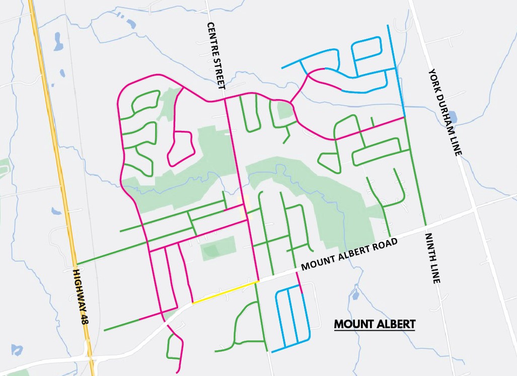
Streets changing to 40km/hr or proposed to be 40km/hr
- Albert Street
- Alice Street
- Arthur Case Crescent
- Bank Street
- Battenberg Court
- Cheltonwood Court
- Cleverdon Boulevard
- Cupples Farm Lane
- Donald Stewart Crescent
- Elizabeth Street
- Frederick Taylor Way
- Gladys Rolling Avenue
- Haig Crescent
- Hammill Heights
- Hi View Drive
- Kingsgate Crescent
- Lilly McKeowan Crescent
- Manor Forest Road
- Manor Glen Crescent
- Margaret Graham Crescent
- Mill Street
- Ninth Line
- Princess Street
- Ridge Gate Crescent
- Robb Thompson Road
- Robert Hunter Crescent
- Royal Amber Crescent
- Royal Oak Road
- Samuel Harper Court
- Shannon Road
- Stokes Road
- Valley Mills Road
- Victoria Street
- Viscount Way
- Vivian Creek Road
- Water Street
School Areas reduced by 10 km/hr
- Mount Albert Public School
Additional Streets
- Bridle Path
- Callwood Court
- Catering Road
- Franklin Road
- Manor Ridge Trail
- Mill Road
- Orchard Court
- Patson Court
- Pelosi Way
- Pine Hill Court
- River Stone Court
- York Street